Turbulent week of weather ahead with 3 different storms tracking across US
ABC News/iStockBY: DANIEL MANZO, ABC NEWS
(NEW YORK) — A turbulent week of weather is ahead with three different major storms expected to track across the United States.
The two biggest takeaways form this extremely active weather pattern includes the increasing likelihood of a long-duration heavy rain and snow event coming to California that could have major impacts to the state.
Already this morning a quick hit of snow is moving through the upper Midwest and is quickly dropping 1 to 3 inches of snow.
The quick round of snow brought hazardous travel conditions to I-80 in Nebraska on Saturday night where ABC News affiliate KETV is reporting an accident caused two deaths and one injury after a car crossed the median and collided with a semi-truck.
There are winter weather alerts being issued this morning with more certainly to be issued in the coming hours.
A storm will bring some more mountain snow and valley rain in the Southern Rockies later Sunday and into Monday.
It will bring snow and ice to parts of the central Plains and Midwest and some additional severe weather will be possible across parts of northern Texas and Oklahoma where, locally, damaging winds and hail will be possible.
By Monday night, the snow and wintry mix will stretch from Iowa to New Jersey with the heaviest snow falling from northern Kansas into parts of Illinois.
Chicago, in particular, could quickly pile up several inches of snow on Monday night and a wintry mix is likely to cause slick roadways from Indianapolis to the Appalachian mountains.
As the storm slides east, it will have some trouble producing snow near the major northeast cities and this likely means that snowfall amounts near Philadelphia and New York will be kept in the low range.
On the snowfall forecast, locally over 6 inches of snow is expected from western Kansas to Chicago and a few areas of 3 to 6 inches is possible from the Kansas-Nebraska Border to Ohio.
It is important to note that the snow totals look quite low near the major northeast Cities and Chicago could easily pick up over 6 inches of snow from this storm on Monday night.
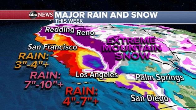
Another storm will quickly move into the western U.S. on Sunday and bring widespread mountain snow and heavy rain from San Francisco to Los Angeles.
Locally, 10 inches of snow will be possible in the southern California mountains later Sunday and Monday which could make travel very treacherous.
As this storm moves across the country, it will bring another quick hit of snow to parts of the Midwest.
Once this storm reaches the East Coast, it remains unclear just how intense the storm will be and exactly where this storm will track.
Some computer models are indicating that a rather powerful storm will develop near the mid-Atlantic and bring at least some snow to the mid-Atlantic states by Thursday.
Given that the models aren’t in agreement on some of the most important details of this setup, uncertainty remains high at this time.
Also by the middle of the week, another separate storm will arrive in California and, as of Sunday morning, this storm looks to be the most concerning.
The storm will bring an atmospheric river of moisture to California that will bring torrential rain and extreme mountain snow for the second half of the week.
One of the biggest concerns is that California saw five of its top six fires by acreage in its history in 2020 and there is a tremendous amount of land there that is susceptible to debris flows and mudslides.
Additionally, there is an excessive rainfall forecast for the week and the region will become more susceptible to flash flooding with locally over 10 inches of snow possible in California this week alone.
Several feet of snow could make travel through mountain passes impossible and quite dangerous.
Copyright © 2021, ABC Audio. All rights reserved.

