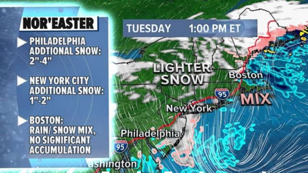
Nor'easter to linger through Tuesday with more snow expected along I-95 corridor
ABC NewsBy MAX GOLEMBO, ABC News
(NEW YORK) — The nor’easter slamming the East Coast is bringing up more than 2 and a half feet of snow, winds of more than 70 mph and coastal flooding.
The highest snowfall was in Newton, New Jersey, where a whopping 32 inches of snow fell.
Elsewhere, Nazareth, Pennsylvania got 31 inches, Harrison, New York got 24.5 inches, Danbury, Connecticut received 19 inches and Wilmington, Massachusetts ended up with 20 inches.
Washington, D.C. had 2.6 inches of snow fall while Philadelphia had 6.8 inches, New York City got 16.3 inches and Boston ended up with 1.2 inches.
There are 19 states that continue to be under winter alerts for snow and ice from Georgia to Maine on Tuesday as this slow coastal storm moves through.
The heaviest snow on Tuesday will be in western and northern New York and into northern New England where more than a half a foot of snow could fall.
A few more inches could even potentially accumulate on I-95 from Philadelphia to New York City.
A new storm is expected to cross the country this week and could bring another bout of snow and heavy rain from the West Coast to the Northeast.
This storm is hitting the West on Tuesday with rain from Seattle to San Francisco as well as some expected snow in the mountains where, locally, a couple of feet of snow is expected in the Sierra Nevada Range in California again.
By Thursday, this storm will hit the central U.S. with more snow and rain for the Midwest and the Great Lakes including Chicago and Minneapolis.
By Friday, this same storm will move to the East Coast with rain for the I-95 corridor and snow for inland areas.
Right after that storm, however, there could be another coastal storm just in time for Super Bowl Sunday, with heavy snow possible even for coastal cities such as New York City.
Copyright © 2021, ABC Audio. All rights reserved.

