Nor'easter brings over a foot of snow to parts of New England
ABC NewsBY: DANIEL MANZO, ABC NEWS
(NEW YORK) — A nor’easter brought heavy rain, strong winds and snow to parts of New England on Saturday.
The impacts from the storm caused hundreds of thousands of power outages and accidents across the region.
A wide swath of heavy snow was reported in parts of eastern New England from the storm with many locations from eastern Connecticut to Maine seeing 8 to 10 inches of snow.
Some of the more extreme snowfall totals include, locally, over a foot of snow in Worcester County, Massachusetts, and 10 inches of snow Union, Connecticut.
Wind gusts across the region were peaking at 40 to 50 mph but along the coast line the gusts where even higher, especially around Cape Cod where winds gusted up to 68 mph.
Precipitation fell mainly as rain from Delaware to New York City with widespread rain totals of 1 to 2 inches.
Attention now turns to the new critical fire threat that is on the way to Southern California on Monday and Tuesday.
Winds on both days could reach locally 70 mph in the mountains in southern California where low relative humidity is expected.
This combination could lead to rapid fire spread and there are critical fire conditions expected both days.
Meanwhile in the rest of the country, there will be a brief break in truly widespread impactful weather.
A few different systems will rapidly move through the southeast in the next 30 hours with the most noteworthy impact being some strong to severe storms across parts of Florida late Sunday into Monday.
There could be some snow showers across parts of the Central Appalachians and into parts of Virginia early Monday morning as well.
Accumulations are expected to be light as these systems race off into the open Atlantic Ocean.
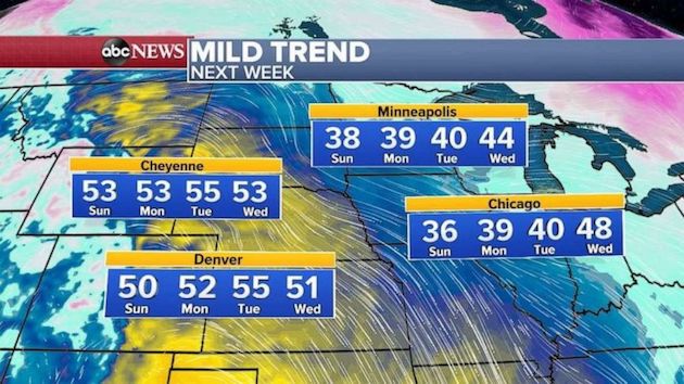
In the Central U.S., a notable mild trend is occurring with temperatures expected to run about 10 to 15 degrees above average in the next few days.
Denver and Cheyenne are both expected to see temperatures into the 50s for the beginning of this week.
Minneapolis and Chicago will be making a run at the upper 40s by Tuesday and Wednesday.
The next widespread weather event looks possible by the second half of the upcoming week when, perhaps, ingredients for a large storm will come together over parts of the central U.S. tracking eastward by next weekend.
Copyright © 2020, ABC Audio. All rights reserved.

